
By Wendy Diaz, EMGV
There were many adjustments to my gardening practices when I moved to North Carolina from Ontario, Canada. The obvious list included: choosing plants that could withstand our hot humid summers, refraining from naively introducing invasive species into the landscape, getting accustomed to green grass in the winter and spring rather than in the summer and fall, regular pruning to keep up to the much faster plant growth rate and adding lime to increase the pH of the soil. Perhaps the biggest adjustment this former Southern Ontario gardener had to make was the constant modification of our abundant heavy clay soils with organic matter; black rich topsoil was readily available where I grew up although it required the removal of an occasional rock (a legacy of glaciation that only reached as far south as Kentucky). With the urging of my fellow Master Gardener blogger and because of my former professional role as a geologist, I decided to research the origins of our ubiquitous clay soil of which an understanding is essential in order to properly manage it and become a successful Durham gardener.
Durham County is underlain by sedimentary rock (material derived from pre-existing rocks and generally deposited by a liquid) formed in a Triassic Basin that extends from southern Granville County southwest to northern Moore County. These rocks started to form about 220 million years ago during the Late Triassic Period when faulting and rifting occurred as the Africa and North America plates drifted apart (breaking up of the supercontinent Pangea) and caused cracks in the Earth’s crust forming rift basins. One basin continued to widen and eventually filled with ocean water to form the Atlantic Ocean, others such as the Deep River Basin (of which Durham is sub-basin) stopped growing and eventually filled in with sediment carried by rivers. About 205 million years ago, during the early Jurassic period, diabase rock dykes and sills formed when basaltic magma intruded into these sedimentary rocks. When the earth’s crust thinned due to spreading of the plates it resulted in the partial melting of the upper mantle producing the basaltic magma.
Generalized_Geologic_Map of North Carolina
The Triassic sediments easily eroded when weathered and the decomposition of this parent material in-situ created poorly-drained acidic clay soils. Very few outcrops of the Triassic rocks are visible because they erode and crumble so easily but there is one on the East Side of South Roxboro Road in the Hope Valley Farms North neighborhood and beneath the Fayetteville Street bridge along the American Tobacco Trail near the Fayetteville trail access. An exception to our acidic clay soil in Durham is the rare alkaline soil derived from the weathering of the diabase sills (Penny’s Bend on the Eno River) which has a high calcium content from the weathering of plagioclase feldspar resulting in higher pH soil above 7 (but that is for another article).
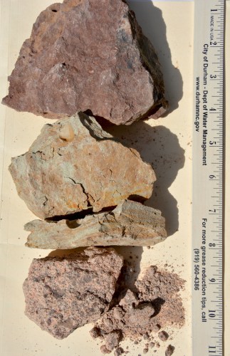
The Triassic consolidated sediments or the bedrock underlying Durham County is mostly composed of inter-bedded reddish-brown sandstone, siltstone and mudstone. These friable rocks rapidly weather in a warm humid climate. The warm humid climate also caused the soils derived from these rocks to be strongly weathered, leached and acidic (pH 4.8 to 5.3); however, native forest vegetation decomposition aided in addition of nutrient minerals to the soil. Most of Durham County is underlain with the White Store Series soil type characterized by yellowish-brown clay loam surface layer and reddish brown subsoil with low organic matter content, slow permeability and rapid runoff. The dominant clay mineral in the White Store series is smectite (formerly montmorillonite) that causes the soil to typically exhibit poor drainage and high shrink-swell potential.

Clay is a term with both mineralogical and textural (grain-size) meanings. Clay size refers to soil grains, of any type of mineral, which are less than 0.002 mm in diameter (or less than 1/256 mm). These grains are microscopic and distinct minerals are identified by X-ray techniques. The general term ‘clay’ refers to crystalline substances or clay minerals, which are hydrous aluminum silicate minerals found in varying proportions in the clay soil. Clay has plastic properties due to its mineralogy and can be easily molded into a desired shape when wet.

The clay mineral group is part of a larger group of minerals known as phyllosilicates. The name is derived from the Greek word phyllon meaning leaf and refers to the typical platy or flaky habit and the one prominent cleavage of these minerals. (Cleavage is the tendency of a mineral to break along a definite plane surface that is dependent on its internal crystal structure.) Phyllosilicates or sheet silicates are generally soft and flexible minerals. The minerals have a lattice structure where the atoms are arranged in layers like a stack of plates or playing cards. The building blocks of aluminum silicate minerals (clay minerals) are the alternating layers of silica tetrahedrons where four oxygen atoms bind with one silicon atom at the center in a four-sided tetrahedral shape and the aluminum octahedron where six hydroxyls (OH) bind with one aluminum atom in the center of the octahedral shape. Each tetrahedron is connected at three corners in the same plane by sharing oxygen anions forming a hexagonal network called a tetrahedral sheet or ‘T’ sheet. Similarly, aluminum octohedrons linked together form an octahedral sheet or ‘O’ sheet.

http://www.groundwaterresearch.com.au/reference_files/hydrology_and_the_clay_minerals/structure.htm
Common clay minerals (smectite) in Durham clay soil form a lattice of T-O-T layers where octahedral Aluminum is partially replaced by magnesium atoms. Each T-O-T layer is loosely held together by van der Waals bonds where cations and water can substitute the Al3+ cation with the lower valence Mg2+ cation (isomorphous replacement) resulting in a negative charge at the location of the substituted atom which is then balanced by an exchangeable cation (Ca2+ or Na+) on the surface or exterior of the layers or sheets. Because of the deficiency of negative charge balance on the mineral structures clay minerals absorb certain ions and retain them on the exterior of their structural unit in an exchangeable state. Their crystal structure allows it to absorb polar water molecules by attracting them to the charged surfaces between sheets that cause it to expand the crystal structure.

Clay minerals also align in a parallel arrangement to pressure and thus reduce porosity when wet clay soils are compacted. The fine grain size of clay means it has abundant surface area and holds water and nutrients effectively and affects the chemical reactivity of the soil with the presence of an electrical charge. The negative charge on the soil is called the cation exchange capacity (CEC) and these clays have a relatively high CEC so they can hold more nutrients (K+, Ca2+, NH4+), however, they tend not to hold anions and water moving through the clay will leach negatively charged nutrients (chloride, nitrate and sulfate).
Our clay soil may require the constant addition of organic matter but it also offers other important attributes for growing plants and I will shovel compost over snow any day!

References:
Exploring the Geology of the Carolinas, A Field Guide to Favorite Places from Chimney Rock to Charleston; Kevin G. Stewart and Mary-Russell Roberson
Generalized geologic map of North Carolina http://digital.ncdcr.gov/cdm/ref/collection/p16062coll9/id/220297
Sedimentary Rocks, third edition F.J. Pettijohn1975 Harper & Row
Geologic Map of Southwest Durham 7.5-Minute Quadrangle, Durham and Orange Counties, North Carolina by Charles W. Hoffman and Patricia E. Gallagher, Digital representation by Michael A. Medina, 2001; North Carolina Geological Survey Open File Report 2001-XX
Manual Of Mineralogy 19th edition Cornelius S. Hurlbut, Jr. Cornelis Klein
Urban Horticulture Note No. 3 AMENDING CLAY SOILS https://durham.ces.ncsu.edu/files/library/32/UNH%203.PDF
Urban Horticulture Note No. 2 DURHAM’S SOIL https://durham.ces.ncsu.edu/files/library/32/UNH%202.PDF
North Carolina Extension Gardener Handbook; Publication date: Feb. 14, 2018 AG-831 https://content.ces.ncsu.edu/extension-gardener-handbook/1-soils-and-plant-nutrients#section_heading_7238
Soil Survey of Durham County North Carolina United States Department of Agriculture Soil Conservation Service https://www.nrcs.usda.gov/Internet/FSE_MANUSCRIPTS/north_carolina/durhamNC1976/durham.pdf
Encyclopedia of Soil Science; CD Barton and A.D. Karathanasis https://www.srs.fs.usda.gov/pubs/ja/ja_barton002.pdf